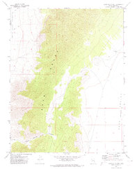
1971 Map of Cave Valley Well
USGS Topo · Published 1974About this map
Egan Range peaks dominate this high-desert landscape along the border of Nye and Lincoln Counties. In the early 1970s, this remote Basin and Range terrain was characterized by dramatic elevation shifts, falling from the rugged limestone slopes of the range into the wide basin of Cave Valley. A central feature of the valley floor is Cave Valley Well, a critical water point in an otherwise arid environment. The map records the primitive transport network of the era, consisting primarily of a Jeep Trail that skirts the mountain base and leads into the drainage of Trough Spring Canyon. This survey captures the region before significant modern development, showing the sheer isolation of the eastern Nevada interior where topography dictated the path of travel between mountain and sink.
Find a feature on this map
6 named features on this map. Tap any name to fly to it.
Don’t see what you’re looking for? This feature index may not catch every label — zoom into the map to look around manually.
Map Details
Editions of this 1971 Cave Valley Well Map
2 editions found
Other maps of this area

1956 · Lund
USGS Topo · 1:250,000

1960 · Lund
USGS Topo · 1:250,000

1969 · Gap Mountain
USGS Topo · 1:24,000

1969 · Shingle Pass
USGS Topo · 1:24,000

1969 · Sunnyside
USGS Topo · 1:24,000

1969 · Moorman Spring SE
USGS Topo · 1:24,000

1969 · Shingle Pass SE
USGS Topo · 1:24,000

1971 · Sidehill Spring
USGS Topo · 1:24,000

1971 · Cave Valley Well
USGS Topo · 1:24,000

1971 · Sidehill Pass
USGS Topo · 1:24,000