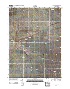
2011 Map of Caviatta Ridge
USGS Topo · Published 2011About this map
Caviatta Ridge defines the high ground of this high-desert Malheur County landscape, where the scarcity of water is reflected in a network of named springs, reservoirs, and catchment basins. At this time, the region's economy and survival relied on scattered water sources like the Deadman Water Hole and Mustang Water Hole, essential for livestock and local wildlife. Infrastructure is minimal, dominated by unpaved routes such as Mustang Reservoir Rd and various water-management sites including the Crows Nest Reservoir and Peacock Pond Reservoir. To the east, Garlow Butte stands as a prominent topographical marker near the Garlow Butte Spring. The drainage patterns of Dry Creek and Peacock Creek illustrate the seasonal nature of the local hydrology, feeding into more permanent engineered features like the White Cow Pit Reservoir and Echave Reservoir.
Find a feature on this map
15 named features on this map. Tap any name to fly to it.
Don’t see what you’re looking for? This feature index may not catch every label — zoom into the map to look around manually.
Map Details
Editions of this 2011 Caviatta Ridge Map
This is the sole edition of this map. No revisions or reprints were ever made.
Other maps of this area

1955 · Jordan Valley
USGS Topo · 1:250,000

1957 · Jordan Valley
USGS Topo · 1:250,000

1958 · Jordan Valley
USGS Topo · 1:250,000

1979 · Rockhouse Reservoir
USGS Topo · 1:24,000
1980 · Skull Creek
USGS Topo · 1:24,000
1980 · Caviatta Ridge
USGS Topo · 1:24,000
1980 · Jackies Butte
USGS Topo · 1:24,000
1980 · Squaw Flat
USGS Topo · 1:24,000
1980 · Indian Fort
USGS Topo · 1:24,000

1982 · Rattlesnake Canyon
USGS Topo · 1:24,000