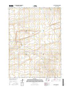
2017 Map of Caviatta Ridge
USGS Topo · Published 2017About this map
Caviatta Ridge and Garlow Butte dominate this high desert landscape in Malheur County, where the scarcity of water is the defining characteristic of the terrain. The distribution of essential water sources like Mustang Water Hole and Garlow Butte Spring indicates the vital infrastructure needed for land management and livestock in this arid environment. The map details a network of man-made catchments, including the curiously named Dry Hole Reservoir, White Cow Pit Reservoir, and Echave Reservoir. Transport through this remote section of Oregon is limited to primitive routes such as Skull Creek Rd and Mustang Reservoir Rd, which navigate the drainages of Peacock Cr and Dry Cr. This 2017 survey provides a precise look at the modern range improvements and topographic features that sustain the high plains of the American West.
Find a feature on this map
20 named features on this map. Tap any name to fly to it.
Don’t see what you’re looking for? This feature index may not catch every label — zoom into the map to look around manually.
Map Details
Editions of this 2017 Caviatta Ridge Map
This is the sole edition of this map. No revisions or reprints were ever made.
Other maps of this area

1955 · Jordan Valley
USGS Topo · 1:250,000

1957 · Jordan Valley
USGS Topo · 1:250,000

1958 · Jordan Valley
USGS Topo · 1:250,000

1979 · Rockhouse Reservoir
USGS Topo · 1:24,000
1980 · Skull Creek
USGS Topo · 1:24,000
1980 · Caviatta Ridge
USGS Topo · 1:24,000
1980 · Jackies Butte
USGS Topo · 1:24,000
1980 · Squaw Flat
USGS Topo · 1:24,000
1980 · Indian Fort
USGS Topo · 1:24,000

1982 · Rattlesnake Canyon
USGS Topo · 1:24,000