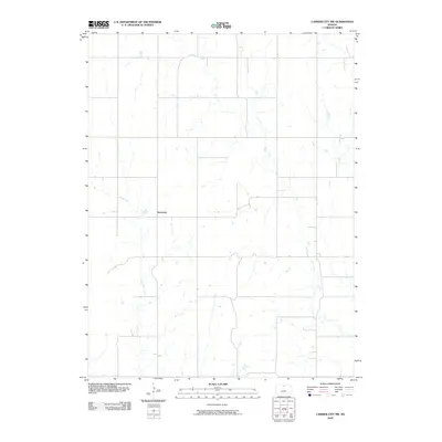
2009 Map of Cawker City NW
USGS Topo · Published 2009About this map
Dentonia serves as the primary focal point of this agricultural landscape in Jewell County, situated amidst a network of prairie waterways. The terrain is defined by the drainage patterns of several tributaries, most notably Little Oak Creek to the west and the diverging branches of West Limestone Creek and Middle Limestone Creek to the east. A subtle grid of section-line roads structures the territory, reflecting the enduring legacy of the Public Land Survey System in rural Kansas. In the northern reaches, Porcupine Creek meanders across the plain, illustrating the typical hydrology of the region before these waters eventually join larger basins to the south. The map documents the sparse but persistent settlement pattern of the early twenty-first century, where isolated farmsteads remain connected by a rigid transport network designed for large-scale farming.
Find a feature on this map
5 named features on this map. Tap any name to fly to it.
Don’t see what you’re looking for? This feature index may not catch every label — zoom into the map to look around manually.
Map Details
Editions of this 2009 Cawker City NW Map
This is the sole edition of this map. No revisions or reprints were ever made.
Other maps of this area

1893 · Smith Center
USGS Topo · 1:125,000

1894 · Mankato
USGS Topo · 1:125,000

1955 · Beloit
USGS Topo · 1:250,000

1959 · Beloit
USGS Topo · 1:250,000

1960 · Downs North
USGS Topo · 1:24,000

1962 · Cawker City
USGS Topo · 1:24,000

1962 · Glen Elder North
USGS Topo · 1:24,000

1968 · Burr Oak
USGS Topo · 1:24,000
1969 · Ionia
USGS Topo · 1:24,000
1969 · Cawker City NW
USGS Topo · 1:24,000