
1960 Map of Downs North
USGS Topo · Published 1962About this map
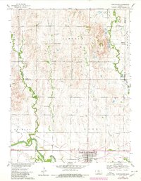
The confluence of the North Fork Solomon River and South Fork Solomon River anchors this 1960s study of the north central Kansas plains. The landscape is defined by the grid of township boundaries including Lincoln and Ross, where the city of Downs serves as a local hub. The southern edge of the map follows the Missouri Pacific railroad as it parallels the river valleys. This era shows a rural landscape still supported by small community centers like Dispatch and a network of neighborhood institutions. Genealogists will find notable value in the specific placement of the Rose Valley Cem, Oakdale Cem, and Downs Cem. Educational history is preserved through labels for several country schoolhouses, such as Oak Creek Sch and Twelvemile Sch, which mark the centers of late-nineteenth-century settlement clusters before widespread district consolidation.
Find a feature on this map
24 named features on this map. Tap any name to fly to it.
Don’t see what you’re looking for? This feature index may not catch every label — zoom into the map to look around manually.
Map Details
Editions of this 1960 Downs North Map
2 editions found
Other maps of this area

1893 · Smith Center
USGS Topo · 1:125,000

1894 · Mankato
USGS Topo · 1:125,000

1894 · Beloit
USGS Topo · 1:125,000

1896 · Osborne
USGS Topo · 1:125,000

1953 · Downs South
USGS Topo · 1:24,000

1953 · Waconda Springs
USGS Topo · 1:24,000

1953 · Osborne
USGS Topo · 1:24,000

1955 · Beloit
USGS Topo · 1:250,000

1959 · Beloit
USGS Topo · 1:250,000

1961 · Portis
USGS Topo · 1:24,000