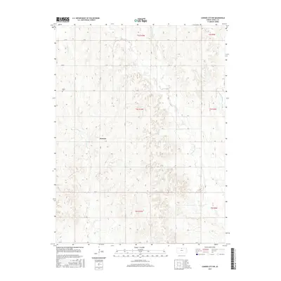
2015 Map of Cawker City NW
USGS Topo · Published 2015About this map
Dentonia serves as the primary point of settlement in this rural expanse of north-central Kansas, where the landscape is defined by the headwaters of several drainages. The topography is shaped by the winding courses of Little Oak Cr and Porcupine Cr, which carve through the plains of Jewell County. Established road networks follow the section lines of the Public Land Survey System, including 190 Rd and 270 Rd, providing a framework for the agricultural homesteads that have long characterized the region. In the northwestern portion of the map, the Odessa Cem remains a significant landmark for genealogical research, marking the location of early community roots near the upper reaches of the creek systems. The map also detail the intricate flow of W Limestone Cr and Middle Limestone Cr, illustrating the vital water resources that supported local development.
Find a feature on this map
23 named features on this map. Tap any name to fly to it.
Don’t see what you’re looking for? This feature index may not catch every label — zoom into the map to look around manually.
Map Details
Editions of this 2015 Cawker City NW Map
This is the sole edition of this map. No revisions or reprints were ever made.
Other maps of this area

1893 · Smith Center
USGS Topo · 1:125,000

1894 · Mankato
USGS Topo · 1:125,000

1955 · Beloit
USGS Topo · 1:250,000

1959 · Beloit
USGS Topo · 1:250,000

1960 · Downs North
USGS Topo · 1:24,000

1962 · Cawker City
USGS Topo · 1:24,000

1962 · Glen Elder North
USGS Topo · 1:24,000

1968 · Burr Oak
USGS Topo · 1:24,000
1969 · Ionia
USGS Topo · 1:24,000
1969 · Cawker City NW
USGS Topo · 1:24,000