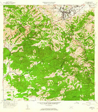
1960 Map of Cayey
USGS Topo · Published 1962About this map
The mountain town of Cayey serves as a focal point in this 1960 topographic study, which captures the intersection of urban growth and agricultural tradition. To the north, the residential sectors of Pueblo Norte and Pueblo Sur are densely mapped, featuring civil landmarks like the Escuela Rexford G Tugwell and the expansive Henry Barracks Military Res. The map documents a transition from the town center into the Sierra de Cayey, where the landscape is defined by coffee and tobacco-growing heritage at Hacienda Clavell and Hacienda Húcar.
Find a feature on this map
79 named features on this map. Tap any name to fly to it.
Don’t see what you’re looking for? This feature index may not catch every label — zoom into the map to look around manually.
Map Details
Editions of this 1960 Cayey Map
This is the sole edition of this map. No revisions or reprints were ever made.
Other maps of this area

1945 · Central Aguirre
USGS Topo · 1:30,000

1945 · Salinas
USGS Topo · 1:30,000

1946 · Patillas
USGS Topo · 1:30,000

1946 · Coamo
USGS Topo · 1:30,000

1946 · Barranquitas
USGS Topo · 1:30,000

1946 · Cayey
USGS Topo · 1:30,000

1946 · Comerio
USGS Topo · 1:30,000

1946 · Guayama
USGS Topo · 1:30,000

1946 · Caguas
USGS Topo · 1:30,000

1947 · Cayey NO
USGS Topo · 1:10,000
Featured Places
- Cayey
- Alturas de Cantera, Cayey
- Sector Rústico Rivera, Cayey
- Sector La Sierra, Aibonito
- Sector Ramón Malavé, Cayey