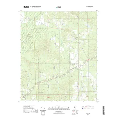
2020 Map of Cayuga
USGS Topo · Published 2020About this map
Cayuga sits at the intersection of local routes in a landscape defined by the winding course of the Big Black River and the sweeping curve of the Natchez Trace Pkwy. This rural region in Mississippi, where Hinds, Warren, and Claiborne Counties meet, is characterized by its numerous small creek drainages like Fivemile Cr and McKee Cr. The map reveals a high density of small family or community burial grounds, including Belmont Cem, McElwee Cem, and Chatham Cem, which provide significant markers for genealogical research. The settlement pattern follows older paths such as Old Port Gibson Rd, which predates the modern parkway, and connects small communities like Reganton and Newman to the surrounding hills and river bottomlands.
Find a feature on this map
62 named features on this map. Tap any name to fly to it.
Don’t see what you’re looking for? This feature index may not catch every label — zoom into the map to look around manually.
Map Details
Editions of this 2020 Cayuga Map
This is the sole edition of this map. No revisions or reprints were ever made.
Other maps of this area

1918 · Vicksburg
USGS Topo · 1:62,500

1938 · Edwards
USGS Topo · 1:62,500

1939 · Yokena
USGS Topo · 1:62,500

1941 · Vicksburg
USGS Topo · 1:62,500

1955 · Jackson
USGS Topo · 1:250,000

1961 · Jackson
USGS Topo · 1:250,000

1962 · Jackson
USGS Topo · 1:250,000

1962 · Vicksburg East
USGS Topo · 1:24,000

1962 · Utica West
USGS Topo · 1:24,000

1963 · Carlisle
USGS Topo · 1:24,000