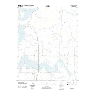
2010 Map of Cayuga
USGS Topo · Published 2010About this map
The Grand Lake O' The Cherokees dominates this landscape where the Neosho River and Elk River converge. Settlement patterns are concentrated around small communities such as Cayuga and Turkey Ford, with the northern reaches of the reservoir creating a complex shoreline at Wolf Point and Council Hollow. The presence of the Howard Cemetery and Cowskin Bridge provides specific points of interest for those tracing the development of this riverfront area. Moving away from the water, the terrain transitions into the Fisher Flats and the elevated White River Hills to the southeast. This survey records a network of rural roads, such as Cayuga Rd, that link these scattered residential clusters and landmarks like Camp Cherokee, illustrating the balance between seasonal recreation and established local residency in this part of Delaware County.
Find a feature on this map
44 named features on this map. Tap any name to fly to it.
Don’t see what you’re looking for? This feature index may not catch every label — zoom into the map to look around manually.
Map Details
Editions of this 2010 Cayuga Map
This is the sole edition of this map. No revisions or reprints were ever made.
Other maps of this area

1907 · Wyandotte
USGS Topo · 1:125,000

1909 · Wyandotte
USGS Topo · 1:125,000

1949 · Seneca
USGS Topo · 1:24,000

1950 · Seneca
USGS Topo · 1:24,000

1954 · Tulsa
USGS Topo · 1:250,000

1958 · Tulsa
USGS Topo · 1:250,000

1961 · Miami SE
USGS Topo · 1:24,000

1961 · Wyandotte
USGS Topo · 1:24,000

1963 · Tulsa
USGS Topo · 1:250,000
1964 · Cayuga
USGS Topo · 1:24,000