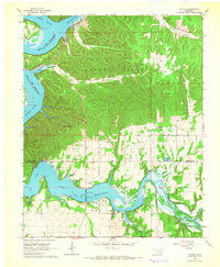
1964 Map of Cayuga
USGS Topo · Published 1966About this map
Indian Ceremonial Grounds and the rural community of Cayuga anchor the southern reaches of this landscape where the Elk River flows toward its confluence. The 1960s terrain is defined by the expansive waters of Lake O' the Cherokees, which fills the deep valleys of the Neosho River and its many winding tributaries like Sycamore Creek and Council Cove.
Find a feature on this map
27 named features on this map. Tap any name to fly to it.
Don’t see what you’re looking for? This feature index may not catch every label — zoom into the map to look around manually.
Map Details
Editions of this 1964 Cayuga Map
2 editions found
Other maps of this area

1907 · Wyandotte
USGS Topo · 1:125,000

1909 · Wyandotte
USGS Topo · 1:125,000

1949 · Seneca
USGS Topo · 1:24,000

1950 · Seneca
USGS Topo · 1:24,000

1954 · Tulsa
USGS Topo · 1:250,000

1958 · Tulsa
USGS Topo · 1:250,000

1961 · Miami SE
USGS Topo · 1:24,000

1961 · Wyandotte
USGS Topo · 1:24,000

1963 · Tulsa
USGS Topo · 1:250,000

1964 · Dodge
USGS Topo · 1:24,000