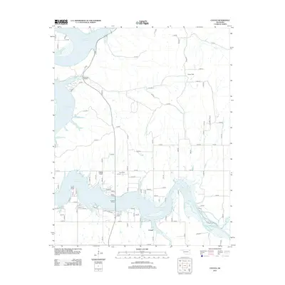
2012 Map of Cayuga
USGS Topo · Published 2012About this map
Cayuga and Turkey Ford anchor this northeastern Oklahoma landscape, where the sprawling fingers of Grand Lake O' the Cherokees reach into the surrounding plains. The 2012 topography shows a transition from the structured residential clusters near Wolf Point to the broader agricultural expanses of Fisher Flats in the east. This era's infrastructure is defined by a dense grid of county roads that navigate the complex shoreline, including the passage over Cowskin Bridge. Genealogy and local history are preserved at the Howard Cem north of the lake, while the northern reaches of the quadrangle feature the more secluded drainage of Brush Cr and the settlement at Council Hollow. The map illustrates how late-20th-century development has integrated with the natural inlets of Lake O' the Cherokees, creating a distinct pattern of peninsula-based communities.
Find a feature on this map
90 named features on this map. Tap any name to fly to it.
Don’t see what you’re looking for? This feature index may not catch every label — zoom into the map to look around manually.
Map Details
Editions of this 2012 Cayuga Map
This is the sole edition of this map. No revisions or reprints were ever made.
Other maps of this area

1907 · Wyandotte
USGS Topo · 1:125,000

1909 · Wyandotte
USGS Topo · 1:125,000

1949 · Seneca
USGS Topo · 1:24,000

1950 · Seneca
USGS Topo · 1:24,000

1954 · Tulsa
USGS Topo · 1:250,000

1958 · Tulsa
USGS Topo · 1:250,000

1961 · Miami SE
USGS Topo · 1:24,000

1961 · Wyandotte
USGS Topo · 1:24,000

1963 · Tulsa
USGS Topo · 1:250,000
1964 · Cayuga
USGS Topo · 1:24,000