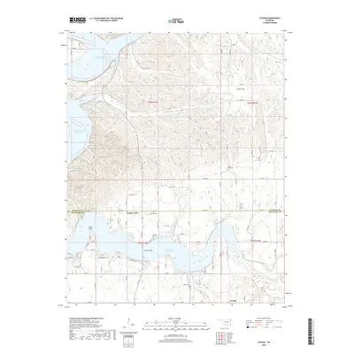
2018 Map of Cayuga
USGS Topo · Published 2018About this map
Turkey Ford and the settlement of Cayuga anchor this northeast Oklahoma landscape where the waters of the Neosho and Elk Rivers meet. The terrain is defined by the expansive reaches of Grand Lake O' the Cherokees, also labeled as Lake O' the Cherokees, which fills the winding valleys once occupied by river bends. This modern topographic record reveals a quiet rural landscape preserved through several family and community landmarks, including Bassett Grove Cem and Council House Cem. The crossing at Cowskin Bridge serves as a vital link across the water, connecting the ridges of Fisher Flats and the drainage of Council Hollow. This survey captures the boundary between Ottawa and Delaware counties, reflecting a region where modern water management has reshaped traditional settlement patterns while leaving historic cemeteries and local place names intact.
Find a feature on this map
77 named features on this map. Tap any name to fly to it.
Don’t see what you’re looking for? This feature index may not catch every label — zoom into the map to look around manually.
Map Details
Editions of this 2018 Cayuga Map
This is the sole edition of this map. No revisions or reprints were ever made.
Other maps of this area

1907 · Wyandotte
USGS Topo · 1:125,000

1909 · Wyandotte
USGS Topo · 1:125,000

1949 · Seneca
USGS Topo · 1:24,000

1950 · Seneca
USGS Topo · 1:24,000

1954 · Tulsa
USGS Topo · 1:250,000

1958 · Tulsa
USGS Topo · 1:250,000

1961 · Miami SE
USGS Topo · 1:24,000

1961 · Wyandotte
USGS Topo · 1:24,000

1963 · Tulsa
USGS Topo · 1:250,000
1964 · Cayuga
USGS Topo · 1:24,000