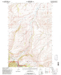
1995 Map of Cayuse Basin
USGS Topo · Published 1997About this map
The Judith Ranger District within the Lewis and Clark National Forest dominates this mid-1990s landscape, where complex drainage systems and sharp topography define the Montana wilderness. The area is characterized by deep coulees, such as Dunsmore Coulee and Nickelson Coulee, which channel seasonal water toward major tributaries like Running Wolf Creek and the North Fork Willow Creek. High points like Steamboat Butte and Skull Butte provide significant vertical relief overlooking the Cayuse Basin. Resource extraction and land management are evident through the presence of a Gravel Pit, scattered prospect markers, and mines located near the intersection of these waterways. The network of 4wd tracks and forest trails provides the only access into these remote canyons and basins.
Find a feature on this map
39 named features on this map. Tap any name to fly to it.
Don’t see what you’re looking for? This feature index may not catch every label — zoom into the map to look around manually.
Map Details
Editions of this 1995 Cayuse Basin Map
This is the sole edition of this map. No revisions or reprints were ever made.
Other maps of this area

1886 · Little Belt Mts.
USGS Topo · 1:250,000

1890 · Fort Benton
USGS Topo · 1:250,000

1892 · Fort Benton
USGS Topo · 1:250,000

1894 · Little Belt Mts.
USGS Topo · 1:250,000

1897 · Fort Benton
USGS Topo · 1:250,000

1897 · Little Belt Mts.
USGS Topo · 1:250,000

1898 · Little Belt Mts.
USGS Topo · 1:250,000

1902 · Little Belt Mts.
USGS Topo · 1:250,000

1948 · White Sulphur Springs
USGS Topo · 1:250,000

1954 · Great Falls
USGS Topo · 1:250,000