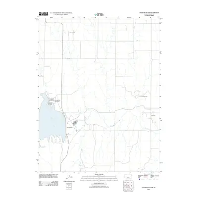
2012 Map of Cedar Bluff Dam
USGS Topo · Published 2012About this map
The Cedar Bluff Dam anchors this part of Trego County, creating the expansive Cedar Bluff Reservoir where the Smoky Hill River is impounded. This landscape is a hybrid of water management and energy production, with the northern and eastern reaches of the quadrangle dominated by petroleum extraction at the Younger Oil Field, Sunny Slope Oil Field, and Groff Oil Field. The reservoir's western shoreline is developed for public recreation, featuring several specialized camping areas including the Wagon Rut Campground, Bluffton Campground, and Broken Spur Campground. Below the dam, the river course continues eastward, joined by Tunnel Creek as it winds through the dissected plains. The map reveals the precise intersection of natural drainage patterns and the artificial geometry of county roads like Co Rd-1747 and Co Rd-571.
Find a feature on this map
12 named features on this map. Tap any name to fly to it.
Don’t see what you’re looking for? This feature index may not catch every label — zoom into the map to look around manually.
Map Details
Editions of this 2012 Cedar Bluff Dam Map
This is the sole edition of this map. No revisions or reprints were ever made.
Other maps of this area

1893 · Ellis
USGS Topo · 1:125,000

1955 · Great Bend
USGS Topo · 1:250,000

1957 · Great Bend
USGS Topo · 1:250,000

1958 · Great Bend
USGS Topo · 1:250,000
1960 · Trego Center NE
USGS Topo · 1:24,000
1961 · Ogallah
USGS Topo · 1:24,000
1961 · Ellis
USGS Topo · 1:24,000
1974 · Cedar Bluff Dam
USGS Topo · 1:24,000
1974 · Cedar Bluff
USGS Topo · 1:24,000
1974 · Ellis SE
USGS Topo · 1:24,000