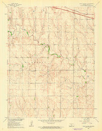
1960 Map of Trego Center NE
USGS Topo · Published 1962About this map
Big Creek winds through the central plains of Trego County, defining the drainage patterns of this high-altitude landscape. In the early 1960s, the area was a mix of traditional agriculture and burgeoning energy extraction, evidenced by the presence of the Ogallah Field and various Gravel Pits scattered across the township lines of Wakeeney and Ogallah. The local community's educational roots are visible at the Trego Center Sch, which served the rural population gathered south of the primary transportation corridors. Along the northern edge of the map, the infrastructure of the Union Pacific railroad and a dedicated Rest Area suggest the importance of transcontinental transit to this part of Kansas. The topography, mapped as part of the Missouri River Basin development program, shows a series of draws and ridges that contrast with the organized grid of section roads and property boundaries.
Find a feature on this map
11 named features on this map. Tap any name to fly to it.
Don’t see what you’re looking for? This feature index may not catch every label — zoom into the map to look around manually.
Map Details
Editions of this 1960 Trego Center NE Map
This is the sole edition of this map. No revisions or reprints were ever made.
Other maps of this area

1893 · Ellis
USGS Topo · 1:125,000

1893 · Hill
USGS Topo · 1:125,000

1955 · Great Bend
USGS Topo · 1:250,000

1955 · Beloit
USGS Topo · 1:250,000

1957 · Great Bend
USGS Topo · 1:250,000

1958 · Great Bend
USGS Topo · 1:250,000

1959 · Beloit
USGS Topo · 1:250,000
1960 · Trego Center
USGS Topo · 1:24,000
1961 · Ogallah
USGS Topo · 1:24,000
1962 · Wa Keeney East
USGS Topo · 1:24,000