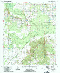
1987 Map of Cedar Bluff
USGS Topo · Published 1987About this map
The Columbus and Greenville railroad corridor defines the central landscape of this 1980s survey, linking the small community of Cedar Bluff with surrounding hamlets like Waddell and Mhoons Valley. Situated on the boundary of Clay Co and Oktibbeha Co, the area is characterized by a dense network of watercourses, including Sun Creek, Cane Creek, and Trim Cane Creek, which meander through a mix of agricultural plots and wooded terrain. Significant local history is preserved in the distribution of family and community landmarks, such as Cumberland Cem and Mosley Cem.
Find a feature on this map
29 named features on this map. Tap any name to fly to it.
Don’t see what you’re looking for? This feature index may not catch every label — zoom into the map to look around manually.
Map Details
Editions of this 1987 Cedar Bluff Map
This is the sole edition of this map. No revisions or reprints were ever made.
Other maps of this area

1953 · West Point
USGS Topo · 1:250,000

1958 · West Point
USGS Topo · 1:250,000

1959 · Artesia
USGS Topo · 1:62,500

1959 · West Point
USGS Topo · 1:62,500

1959 · Pheba
USGS Topo · 1:62,500

1963 · West Point
USGS Topo · 1:250,000

1965 · Starkville
USGS Topo · 1:24,000

1965 · Longview
USGS Topo · 1:24,000

1982 · West Point
USGS Topo · 1:100,000

1984 · West Point
USGS Topo · 1:250,000