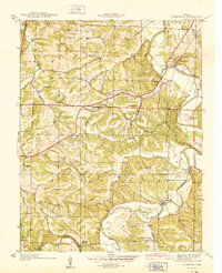
1938 Map of Cedar Hill
USGS Topo · Published 1940About this map
The Big River winds through the heart of Jefferson County in the late 1930s, its meanders defining the agricultural and industrial layout of this rural landscape. At Morse Mill, the river provides a focal point for settlement, while further north, Cedar Hill sits near the confluence of Big River and several tributary creeks. This period reveals a network of country schoolhouses that anchored local communities, including Calvey Sch, Maple Grove Sch, and Mayfield Sch.
Find a feature on this map
32 named features on this map. Tap any name to fly to it.
Don’t see what you’re looking for? This feature index may not catch every label — zoom into the map to look around manually.
Map Details
Editions of this 1938 Cedar Hill Map
2 editions found
Other maps of this area

1901 · De Soto
USGS Topo · 1:125,000

1930 · De Soto NE
USGS Topo · 1:24,000

1930 · Pacific SE
USGS Topo · 1:24,000

1931 · Pacific NE
USGS Topo · 1:24,000

1937 · Pacific
USGS Topo · 1:24,000

1937 · Fletcher
USGS Topo · 1:24,000

1938 · Cedar Hill
USGS Topo · 1:24,000

1938 · Fletcher
USGS Topo · 1:24,000

1940 · Cedar Hill
USGS Topo · 1:24,000

1946 · Richwoods
USGS Topo · 1:62,500