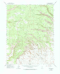
1963 Map of Cedar Mesa
USGS Topo · Published 1974About this map
Cliff Dwellings and numerous Ruins punctuate the deep sandstone incisions of Bullet Canyon and Johns Canyon, documenting a long history of human habitation across the Cedar Mesa plateau. The landscape is defined by vast mesas like Brushy Flat and Todie Flat that drop sharply into the Valley of the Gods, where erosional remnants such as Castle Butte and Balanced Rock stand as prominent landmarks. This 1963 survey captures the area as it transitioned into a recognized recreational destination, with portions of the Glen Canyon Natl Rec Area appearing in the southwest. Historical transit is marked by the Mormon Trail crossing Snow Flat, while more modern industrial explorations are evidenced by several Drill Hole locations. Geological features such as Nevills Arch and the Cigarette Spring Cave highlight the complex topography of the Lime Ridge vicinity.
Find a feature on this map
43 named features on this map. Tap any name to fly to it.
Don’t see what you’re looking for? This feature index may not catch every label — zoom into the map to look around manually.
Map Details
Editions of this 1963 Cedar Mesa Map
2 editions found
Other maps of this area

1886 · Henry Mountains
USGS Topo · 1:250,000

1886 · Abajo
USGS Topo · 1:250,000

1892 · Abajo
USGS Topo · 1:250,000

1892 · Henry Mountains
USGS Topo · 1:250,000

1893 · Abajo
USGS Topo · 1:250,000

1935 · Elk Ridge
USGS Topo · 1:96,000

1940 · Elk Ridge
USGS Topo · 1:125,000

1952 · Natural Bridges
USGS Topo · 1:62,500

1954 · White Canyon 4 SE
USGS Topo · 1:24,000
1954 · Elk Ridge 3 SW
USGS Topo · 1:24,000