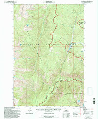
1994 Map of Cedar Ridge
USGS Topo · Published 1997About this map
Selway Bitterroot Wilderness dominates this remote portion of Idaho, where the intersection of the Clearwater National Forest and Nez Perce National Forest creates a landscape defined by sharp elevation changes and deep creek drainages. The Elk Summit Guard Station at Elk Summit stands as a primary point of human presence in a wilderness area otherwise navigated by backcountry routes like the Powell Moose Creek Trail. High-elevation water bodies such as Kidney Lake, Porphyry Lakes, and Goat Lakes are tucked beneath peaks including Hoodoo Mtn and Gateway Peak. The presence of Horse Heaven Meadows and various named ridges like Cedar Ridge and Maple Lake Ridge highlights the diverse topographical features managed by the U.S. Forest Service during the mid-1990s revision period.
Find a feature on this map
33 named features on this map. Tap any name to fly to it.
Don’t see what you’re looking for? This feature index may not catch every label — zoom into the map to look around manually.
Map Details
Editions of this 1994 Cedar Ridge Map
This is the sole edition of this map. No revisions or reprints were ever made.
Other maps of this area

1911 · Lolo
USGS Topo · 1:250,000

1913 · Lolo
USGS Topo · 1:250,000

1956 · Hamilton
USGS Topo · 1:250,000

1959 · Hamilton
USGS Topo · 1:250,000

1960 · Hamilton
USGS Topo · 1:250,000

1964 · Hamilton
USGS Topo · 1:250,000

1966 · Grave Peak
USGS Topo · 1:24,000
1966 · Wahoo Peak
USGS Topo · 1:24,000
1966 · Freeman Peak
USGS Topo · 1:24,000
1966 · Saddle Mtn.
USGS Topo · 1:24,000