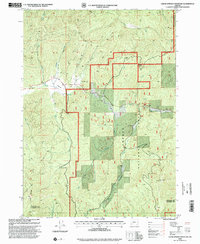
1998 Map of Cedar Springs Mountain
USGS Topo · Published 2000About this map
Koch Ranch and Devils Flat represent the sparse human footprint within the high timberlands of the Umpqua National Forest as it was mapped in the late 1990s. This drainage-heavy landscape is defined by the convergence of numerous forks and creeks, including Cow Creek, Applegate Creek, and Dismal Creek, which carve through a series of prominent peaks such as Cedar Springs Mtn and Ike Butte. The map documents the complex network of forest service access roads, marked by specific distance indicators like Mile 66 and Mile 70, alongside industrial activity at several named Quarry sites. Spanning the Douglas and Jackson county line, the terrain shifts from the wide alluvial character of The Meadows to the steep relief of Castle Rock and Red Mountain, illustrating the watershed's role in the regional timber and ranching economy.
Find a feature on this map
32 named features on this map. Tap any name to fly to it.
Don’t see what you’re looking for? This feature index may not catch every label — zoom into the map to look around manually.
Map Details
Editions of this 1998 Cedar Springs Mountain Map
This is the sole edition of this map. No revisions or reprints were ever made.
Other maps of this area

1891 · Ashland
USGS Topo · 1:250,000

1893 · Ashland
USGS Topo · 1:250,000

1897 · Ashland
USGS Topo · 1:250,000

1904 · Riddle
USGS Topo · 1:125,000

1943 · Trail
USGS Topo · 1:62,500

1944 · Tiller
USGS Topo · 1:62,500

1954 · Days Creek
USGS Topo · 1:62,500

1954 · Wimer
USGS Topo · 1:62,500

1955 · Medford
USGS Topo · 1:250,000

1957 · Medford
USGS Topo · 1:250,000