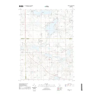
2019 Map of Cement City
USGS Topo · Published 2019About this map
Cement City and the surrounding lake country of southern Michigan are detailed in this contemporary topographic record. The landscape is defined by its glacial hydrology, with Lake Columbia, Clark Lake, and Devils Lake serving as central geographic anchors for the local communities. The map highlights the intersection of Jackson, Lenawee, and Hillsdale counties, tracing the rural road network and residential expansion around waterfronts. Genealogists and local historians can locate several traditional burial grounds including Osborn Cem, Briggs Cem, and Peterson Cem. Prominent topographic markers like Prospect Hill and Irish Hill rise above the drainage systems of the River Raisin and various local drains. The map illustrates the 21st-century character of established settlements like Brooklyn and Clarklake, showing their modern footprints alongside long-standing landmarks.
Find a feature on this map
134 named features on this map. Tap any name to fly to it.
Don’t see what you’re looking for? This feature index may not catch every label — zoom into the map to look around manually.
Map Details
Editions of this 2019 Cement City Map
This is the sole edition of this map. No revisions or reprints were ever made.
Other maps of this area

1935 · Jackson
USGS Topo · 1:48,000

1939 · Jackson
USGS Topo · 1:62,500

1948 · Manchester
USGS Topo · 1:62,500

1949 · Manchester
USGS Topo · 1:62,500

1953 · Fort Wayne
USGS Topo · 1:250,000

1956 · Fort Wayne
USGS Topo · 1:250,000

1958 · Grand Rapids
USGS Topo · 1:250,000

1961 · Grand Rapids
USGS Topo · 1:250,000

1962 · Grand Rapids
USGS Topo · 1:250,000
1962 · Wheatland
USGS Topo · 1:24,000