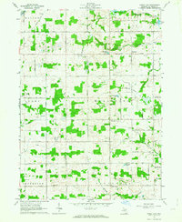
1962 Map of Wheatland
USGS Topo · Published 1963About this map
Churchs Corners and Locust Corners anchor a rural landscape of family farms and woodlots during the early 1960s. This survey, compiled from 1958 aerial photography and field-checked by the USGS, reveals the intricate mesh of agricultural property lines and fencerois indicated by fine red dashed lines. The northeastern corner is bisected by the New York Central Railroad and a corresponding Railroad Grade, providing vital transit through the township. Small crossroads like Wheatland and Beecher appear as clusters of residences, schools, and churches. Water features define the rolling terrain, including Mercer Lakes and Bloomer Lake, while small creeks like St Joseph Creek and various drainage systems such as Mabee Drain demonstrate the sophisticated water management required for this region's productive farmland.
Find a feature on this map
55 named features on this map. Tap any name to fly to it.
Don’t see what you’re looking for? This feature index may not catch every label — zoom into the map to look around manually.
Map Details
Editions of this 1962 Wheatland Map
2 editions found
Other maps of this area

1935 · Jackson
USGS Topo · 1:48,000

1939 · Jackson
USGS Topo · 1:62,500

1948 · Spring Arbor
USGS Topo · 1:62,500

1949 · Spring Arbor
USGS Topo · 1:62,500

1953 · Fort Wayne
USGS Topo · 1:250,000

1956 · Fort Wayne
USGS Topo · 1:250,000

1958 · Grand Rapids
USGS Topo · 1:250,000

1959 · North Adams
USGS Topo · 1:24,000

1959 · Frontier
USGS Topo · 1:24,000

1961 · Grand Rapids
USGS Topo · 1:250,000