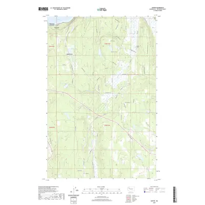
2020 Map of Center
USGS Topo · Published 2020About this map
Discovery Bay defines the northern edge of this Olympic Peninsula landscape, where the waters of the Puget Sound meet the varied terrain of Jefferson County. The settlement of Discovery Junction and nearby Fairmont occupy the northwestern corner, serving as historical points of interest along the bay’s edge. Further inland, the community of Eaglemount sits elevated above Peterson Lake, while the namesake settlement of Center anchors the central valley. The map reveals a complex network of wetlands and small water bodies, including Beausite Lake and Tarboo Lake, which feed the drainages of Chimacum Cr and Tarboo Cr. A distinctive modern recreational feature, the Pacific NW National Scenic Trail, traverses the northern ridges, offering a contrast to the long-established agricultural and rural road networks like Old Eaglemount Rd and Center Rd. Local aviators and history buffs will also note the presence of Stacey's Airport tucked away near Naylor Creek Rd.
Find a feature on this map
63 named features on this map. Tap any name to fly to it.
Don’t see what you’re looking for? This feature index may not catch every label — zoom into the map to look around manually.
Map Details
Editions of this 2020 Center Map
This is the sole edition of this map. No revisions or reprints were ever made.
Other maps of this area

1937 · Port Gamble
USGS Topo · 1:62,500

1939 · Port Townsend
USGS Topo · 1:62,500

1939 · Coupeville
USGS Topo · 1:62,500

1940 · Port Gamble
USGS Topo · 1:62,500

1940 · Quilcene
USGS Topo · 1:62,500

1953 · Quilcene
USGS Topo · 1:24,000

1953 · Mt. Walker
USGS Topo · 1:24,000

1953 · Nordland
USGS Topo · 1:24,000
1953 · Lofall
USGS Topo · 1:24,000

1953 · Center
USGS Topo · 1:24,000