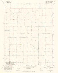
1968 Map of Center North
USGS Topo · Published 1970About this map
Agricultural development and irrigation systems dominate the landscape north of Center, where a complex grid of water management features supports the high-altitude San Luis Valley. The map documents the vital role of the Farmers Union Canal and North Main Canal, alongside the North Lateral and North Central Lateral, in directing water across the level terrain. These man-made channels contrast with the natural path of La Garita Creek and a northern marsh. Local aviation and ranching are represented by the Leach Airport and family-named properties such as Lanier Ranch and Meadow Ranch. Numerous labels for Flowing Well and Flowing Wells illustrate the area's dependence on artesian water sources during this late 1960s period of Colorado history.
Find a feature on this map
15 named features on this map. Tap any name to fly to it.
Don’t see what you’re looking for? This feature index may not catch every label — zoom into the map to look around manually.
Map Details
Editions of this 1968 Center North Map
2 editions found
Other maps of this area

1915 · Del Norte
USGS Topo · 1:125,000

1917 · Del Norte
USGS Topo · 1:125,000

1945 · Durango
USGS Topo · 1:250,000

1953 · Durango
USGS Topo · 1:250,000

1954 · Durango
USGS Topo · 1:250,000

1954 · Trinidad
USGS Topo · 1:250,000

1955 · Trinidad
USGS Topo · 1:250,000

1958 · Trinidad
USGS Topo · 1:250,000

1959 · Trinidad
USGS Topo · 1:250,000

1961 · Durango
USGS Topo · 1:250,000