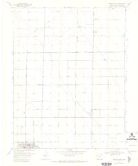
1968 Map of Center North
USGS Topo · Published 1970About this map
Center serves as the focal point for this agricultural region in Saguache County, where a highly organized irrigation network defines the landscape. The intricate system of the North Main Canal, Farmers Union Canal, and various laterals like North Central Lateral and Lateral 47 suggests a landscape transformed by intensive water management. The survey documents the area's rural infrastructure, featuring family-named locations such as Lanier Ranch and Meadow Ranch alongside community essentials like the High Sch and Park. To the east, Leach Airport and a small Landing Area provide aviation access for this San Luis Valley community. The presence of numerous Flowing Wells across the grid highlights the reliance on artesian water to sustain the valley's farms and ranches.
Find a feature on this map
18 named features on this map. Tap any name to fly to it.
Don’t see what you’re looking for? This feature index may not catch every label — zoom into the map to look around manually.
Map Details
Editions of this 1968 Center North Map
2 editions found
Other maps of this area

1915 · Del Norte
USGS Topo · 1:125,000

1917 · Del Norte
USGS Topo · 1:125,000

1945 · Durango
USGS Topo · 1:250,000

1953 · Durango
USGS Topo · 1:250,000

1954 · Durango
USGS Topo · 1:250,000

1954 · Trinidad
USGS Topo · 1:250,000

1955 · Trinidad
USGS Topo · 1:250,000

1958 · Trinidad
USGS Topo · 1:250,000

1959 · Trinidad
USGS Topo · 1:250,000

1961 · Durango
USGS Topo · 1:250,000