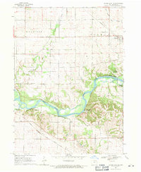
1968 Map of Center Point NW
USGS Topo · Published 1971About this map
The Cedar River carves a dramatic path through the heart of Benton County in the late 1960s, its course lined with recreational spaces like the Wildcat Bluff Recreation Area and Hoefle-Dulin Recreation Area. The township organization of Harrison, Polk, Taylor, and Benton is clearly defined, showing a rural landscape anchored by the town of Urbana and numerous family landmarks. Genealogists will find value in the placement of Kushing Cem and Cox Cem, alongside country churches such as Prairie Creek Ch and Oak Grove Ch. Industrial and transport footprints are evident through the Chicago Rock Island and Pacific railroad line, a local Landing Strip, and several quarries and sandpits that signify the area's geological utility.
Find a feature on this map
27 named features on this map. Tap any name to fly to it.
Don’t see what you’re looking for? This feature index may not catch every label — zoom into the map to look around manually.
Map Details
Editions of this 1968 Center Point NW Map
This is the sole edition of this map. No revisions or reprints were ever made.
Other maps of this area

1888 · Shellsburg
USGS Topo · 1:62,500

1889 · Shellsburg
USGS Topo · 1:62,500

1899 · Shellsburg
USGS Topo · 1:62,500

1903 · Winthrop
USGS Topo · 1:125,000

1954 · Waterloo
USGS Topo · 1:250,000

1955 · Waterloo
USGS Topo · 1:250,000

1959 · Dubuque
USGS Topo · 1:250,000

1961 · Dubuque
USGS Topo · 1:250,000

1962 · Dubuque
USGS Topo · 1:250,000
1968 · Center Point
USGS Topo · 1:24,000