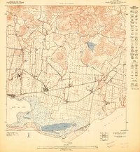
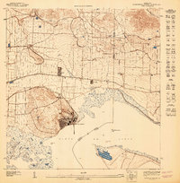
1947 Map of Central Aguirre NE
USGS Topo · Published 1947About this map
Sugarcane agriculture and coastal commerce define this 1940s landscape along the southern coast of Puerto Rico. The infrastructure of the sugar industry is prominent, anchored by Central Guamani and surrounding outposts like Colonia Josefa, Colonia Reunión, and Hacienda Mercedes. A Red Brick Chimney stands as a vertical landmark amongst the organized fields and irrigation networks that draw water from Lago Melania and the Guamani river system.
Find a feature on this map
32 named features on this map. Tap any name to fly to it.
Don’t see what you’re looking for? This feature index may not catch every label — zoom into the map to look around manually.
Map Details
Editions of this 1947 Central Aguirre NE Map
This is the sole edition of this map. No revisions or reprints were ever made.
Other maps of this area

1945 · Central Aguirre
USGS Topo · 1:30,000

1946 · Patillas
USGS Topo · 1:30,000

1946 · Cayey
USGS Topo · 1:30,000

1946 · Guayama
USGS Topo · 1:30,000

1947 · Patillas SO
USGS Topo · 1:10,000
1947 · Guayama NO
USGS Topo · 1:10,000

1947 · Cayey SO
USGS Topo · 1:10,000
1947 · Central Aquirre SO
USGS Topo · 1:10,000
1947 · Cayey SE
USGS Topo · 1:10,000
1947 · Central Aquirre NO
USGS Topo · 1:10,000