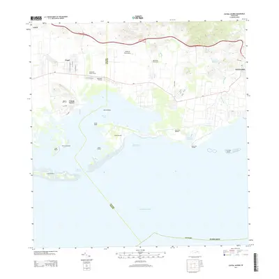
2013 Map of Central Aguirre
USGS Topo · Published 2013About this map
Central Aguirre and the neighboring settlement of Coquí anchor this coastal survey of southern Puerto Rico, where the industrial history of the sugar era meets the Caribbean shoreline. The landscape is defined by the deep indentation of the Bahía de Jobos, protected by the reef-fringed Cayos de Barca and the long peninsula ending at Punta Pozuelo. To the east, the terrain rises toward the outskirts of Guayama, where the Río Guamaní flows toward the coast. Significant maritime features including Boca del Infierno and the Puerto de Las Mareas- Jobos highlight the area's importance as a sheltered harbor. Local landmarks like the Aguirre Golf Club and various named streets such as Calle Betances and Calle Principal provide specific geographic markers for those researching the social and physical layout of these historic company towns and coastal communities.
Find a feature on this map
42 named features on this map. Tap any name to fly to it.
Don’t see what you’re looking for? This feature index may not catch every label — zoom into the map to look around manually.
Map Details
Editions of this 2013 Central Aguirre Map
This is the sole edition of this map. No revisions or reprints were ever made.
Other maps of this area

1945 · Central Aguirre
USGS Topo · 1:30,000

1945 · Salinas
USGS Topo · 1:30,000

1946 · Patillas
USGS Topo · 1:30,000

1946 · Coamo
USGS Topo · 1:30,000

1946 · Cayey
USGS Topo · 1:30,000

1946 · Guayama
USGS Topo · 1:30,000

1947 · Patillas SO
USGS Topo · 1:10,000
1947 · Guayama NO
USGS Topo · 1:10,000
1947 · Central Aguirre NE
USGS Topo · 1:10,000

1947 · Cayey SO
USGS Topo · 1:10,000
Featured Places
- Las Mareas, Guayama
- Cimarrona, Guayama
- Parcelas Viejas de Cimarrona, Guayama
- Estancias de Villa Hermosa, Guayama
- Reunión, Guayama