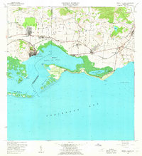
1960 Map of Central Aguirre
USGS Topo · Published 1962About this map
The industrial and agricultural landscape of southern Puerto Rico is centered here on the sugar production hub of Central Aguirre. In the early 1960s, this area was a primary node of the island's coastal economy, featuring the industrial works of Central Aguirre and Central Guamaní alongside the residential clusters of Coquí, San Felipe, and Villodas. The map illustrates a complex water management system essential for irrigation, including the Canal de Patillas and the Lago Melania, which feed into the agricultural lands of Aguirre and Jobos.
Find a feature on this map
60 named features on this map. Tap any name to fly to it.
Don’t see what you’re looking for? This feature index may not catch every label — zoom into the map to look around manually.
Map Details
Editions of this 1960 Central Aguirre Map
2 editions found
Other maps of this area

1945 · Central Aguirre
USGS Topo · 1:30,000

1945 · Salinas
USGS Topo · 1:30,000

1946 · Patillas
USGS Topo · 1:30,000

1946 · Coamo
USGS Topo · 1:30,000

1946 · Cayey
USGS Topo · 1:30,000

1946 · Guayama
USGS Topo · 1:30,000

1947 · Patillas SO
USGS Topo · 1:10,000
1947 · Guayama NO
USGS Topo · 1:10,000
1947 · Central Aguirre NE
USGS Topo · 1:10,000

1947 · Cayey SO
USGS Topo · 1:10,000
Featured Places
- Cimarrona, Guayama
- Parcelas Viejas de Cimarrona, Guayama
- Estancias de Villa Hermosa, Guayama
- Reunión, Guayama
- Las Mareas, Guayama