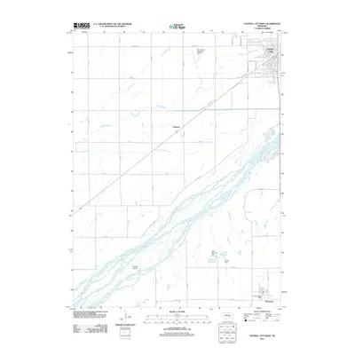
2011 Map of Central City West
USGS Topo · Published 2011About this map
The Platte River dominates this landscape of the Platte Valley, braiding through several channels as it passes Bushes Island. At the northeastern edge of the sheet, Central City serves as a regional hub, its grid layout defined by streets like 18th St and proximity to the Central City Municipal Airport. Agricultural drainage and water management are prominent throughout the region, evidenced by the presence of Warm Slough, Silver Creek, and several reservoirs such as Sherman Reservoir and Larsen Reservoir with their associated dams. The southern portion of the map includes the village of Marquette, where the Marquette Post Office marks the center of local civic life. Smaller crossroads and rural landmarks, such as Paddock, are connected by a network of section-line roads like Lone Tree Rd and Fairgrounds Rd, showing the systematic development of Merrick and Hamilton counties.
Find a feature on this map
46 named features on this map. Tap any name to fly to it.
Don’t see what you’re looking for? This feature index may not catch every label — zoom into the map to look around manually.
Map Details
Editions of this 2011 Central City West Map
This is the sole edition of this map. No revisions or reprints were ever made.
Other maps of this area

1896 · Stromsburg
USGS Topo · 1:125,000

1898 · York
USGS Topo · 1:125,000

1898 · Grand Island
USGS Topo · 1:125,000

1899 · St. Paul
USGS Topo · 1:125,000

1899 · York
USGS Topo · 1:125,000

1955 · Broken Bow
USGS Topo · 1:250,000

1955 · Fremont
USGS Topo · 1:250,000

1955 · Lincoln
USGS Topo · 1:250,000

1955 · Grand Island
USGS Topo · 1:250,000

1956 · Broken Bow
USGS Topo · 1:250,000