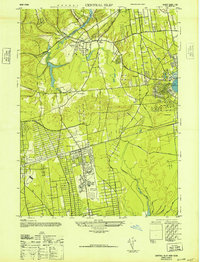
1947 Map of Central Islip
USGS Topo · Published 1947About this map
Central Islip State Hospital dominates the central landscape of this post-war Suffolk County survey, its massive footprint and associated filtration beds illustrating the significant institutional presence in the region during the 1940s. The area is defined by the critical transit corridors of the Long Island Railroad and the Long Island Motor Parkway, which supported the growth of settlements like Brentwood and Central Islip. To the north, the terrain transitions into the more established residential patterns of Smithtown Branch and The Branch, situated near the headwaters of the Nissequogue River. Further east, the map captures the recreational and residential hub surrounding Lake Ronkonkoma, while the southern reaches show the early development of the Islip Airport, signaling the area's increasing connectivity and infrastructure expansion.
Find a feature on this map
28 named features on this map. Tap any name to fly to it.
Don’t see what you’re looking for? This feature index may not catch every label — zoom into the map to look around manually.
Map Details
Editions of this 1947 Central Islip Map
This is the sole edition of this map. No revisions or reprints were ever made.
Other maps of this area

1901 · Babylon
USGS Topo · 1:62,500

1901 · Northport
USGS Topo · 1:62,500

1902 · Setauket
USGS Topo · 1:62,500

1902 · Fire Island
USGS Topo · 1:62,500

1903 · Babylon
USGS Topo · 1:62,500

1903 · Northport
USGS Topo · 1:62,500

1903 · Fire Island
USGS Topo · 1:62,500

1904 · Setauket
USGS Topo · 1:62,500

1904 · Islip
USGS Topo · 1:125,000

1919 · Setauket
USGS Topo · 1:62,500