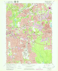
1967 Map of Central Islip
USGS Topo · Published 1979About this map
The Central Islip State Hospital complex dominates the landscape south of the Long Island RR, showcasing the massive institutional footprint that defined this portion of Suffolk County in the mid-20th century. Suburban expansion is evident through the dense grid of residential developments in Brentwood and Hauppauge, yet large green spaces like the Bayard Cutting Arboretum and the New Millpond County Park preserve the area's natural hydrology near the Connetquot River.
Find a feature on this map
85 named features on this map. Tap any name to fly to it.
Don’t see what you’re looking for? This feature index may not catch every label — zoom into the map to look around manually.
Map Details
Editions of this 1967 Central Islip Map
4 editions found
Other maps of this area

1901 · Babylon
USGS Topo · 1:62,500

1901 · Northport
USGS Topo · 1:62,500

1902 · Setauket
USGS Topo · 1:62,500

1902 · Fire Island
USGS Topo · 1:62,500

1903 · Babylon
USGS Topo · 1:62,500

1903 · Northport
USGS Topo · 1:62,500

1903 · Fire Island
USGS Topo · 1:62,500

1904 · Setauket
USGS Topo · 1:62,500

1904 · Islip
USGS Topo · 1:125,000

1919 · Setauket
USGS Topo · 1:62,500