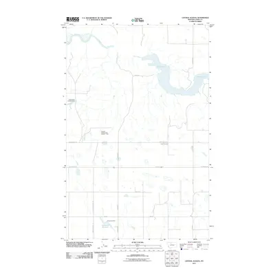
2011 Map of Central School
USGS Topo · Published 2011About this map
Omholt Cemetery stands as a focal point for local history in this part of Toole County, situated south of the sprawling waters of Lake Elwell. The landscape is defined by the managed flow of the Marias River, which feeds into the lake and is controlled by several local water management structures. Named landmarks like the McCracken Brothers Dam and the Loubren Incorporated Number 1 Dam indicate the critical importance of water rights and irrigation in this northern Montana prairie. A grid of rural roads, including Union School Rd and N Central School Rd, connects scattered ranching and agricultural interests. In the southern portion of the quadrangle, the D Ratzburg Reservoir and its associated D Ratzburg Dam provide further evidence of the engineered water systems necessary to support the region's homesteads and farms.
Find a feature on this map
18 named features on this map. Tap any name to fly to it.
Don’t see what you’re looking for? This feature index may not catch every label — zoom into the map to look around manually.
Map Details
Editions of this 2011 Central School Map
This is the sole edition of this map. No revisions or reprints were ever made.
Other maps of this area

1920 · Conrad
USGS Topo · 1:125,000

1954 · Shelby
USGS Topo · 1:250,000

1958 · Shelby
USGS Topo · 1:250,000

1967 · Central School
USGS Topo · 1:24,000

1967 · Conrad Butte
USGS Topo · 1:24,000

1967 · South Devon School
USGS Topo · 1:24,000

1967 · Dunkirk
USGS Topo · 1:24,000

1967 · Fowler Coulee NW
USGS Topo · 1:24,000
1967 · Fowler Coulee NE
USGS Topo · 1:24,000

1970 · Sollid School
USGS Topo · 1:24,000