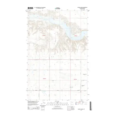
2014 Map of Central School
USGS Topo · Published 2014About this map
Central School serves as a primary landmark in this rural Toole County landscape, where the northern plains are deeply etched by the winding course of the Marias River. The river's flow is punctuated by the expansive Lake Elwell, while the surrounding terrain is defined by a series of drainage features including Hoffman Coulee, Powder Coulee, and East Powder Coulee. This 2014 survey reveals a highly organized grid of rural transport, where family and descriptive names like Ledger Rd, Ratzburg Rd, and S Central School Rd provide access to remote agricultural holdings. Smaller water management features, such as the D Ratzburg Reservoir, and the quiet presence of the Omholt Cem along Union School Rd, underscore the long-term settlement and land-use patterns of this northern Montana region.
Find a feature on this map
24 named features on this map. Tap any name to fly to it.
Don’t see what you’re looking for? This feature index may not catch every label — zoom into the map to look around manually.
Map Details
Editions of this 2014 Central School Map
This is the sole edition of this map. No revisions or reprints were ever made.
Other maps of this area

1920 · Conrad
USGS Topo · 1:125,000

1954 · Shelby
USGS Topo · 1:250,000

1958 · Shelby
USGS Topo · 1:250,000

1967 · Central School
USGS Topo · 1:24,000

1967 · Conrad Butte
USGS Topo · 1:24,000

1967 · South Devon School
USGS Topo · 1:24,000

1967 · Dunkirk
USGS Topo · 1:24,000

1967 · Fowler Coulee NW
USGS Topo · 1:24,000
1967 · Fowler Coulee NE
USGS Topo · 1:24,000

1970 · Sollid School
USGS Topo · 1:24,000