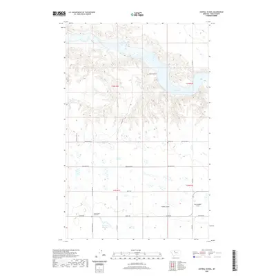
2020 Map of Central School
USGS Topo · Published 2020About this map
Central School (historical) stands as a reminder of early educational infrastructure in Toole County, located south of the meandering Marias River and the northern reaches of Lake Elwell. This landscape is defined by the sharp transition between irrigated agricultural plains and the deeply etched drainage systems of Powder Coulee and East Powder Coulee. The map shows a network of section-line roads, such as Union School Rd and Reclamation Rd, which serve a territory shaped by significant water management projects, including the D Ratzburg Reservoir. For genealogists and local historians, the presence of the Omholt Cem and the Camrose Colony Ln provides concrete evidence of specific community settlements and family legacies in this high-plains environment.
Find a feature on this map
26 named features on this map. Tap any name to fly to it.
Don’t see what you’re looking for? This feature index may not catch every label — zoom into the map to look around manually.
Map Details
Editions of this 2020 Central School Map
This is the sole edition of this map. No revisions or reprints were ever made.
Other maps of this area

1920 · Conrad
USGS Topo · 1:125,000

1954 · Shelby
USGS Topo · 1:250,000

1958 · Shelby
USGS Topo · 1:250,000

1967 · Central School
USGS Topo · 1:24,000

1967 · Conrad Butte
USGS Topo · 1:24,000

1967 · South Devon School
USGS Topo · 1:24,000

1967 · Dunkirk
USGS Topo · 1:24,000

1967 · Fowler Coulee NW
USGS Topo · 1:24,000
1967 · Fowler Coulee NE
USGS Topo · 1:24,000

1970 · Sollid School
USGS Topo · 1:24,000