
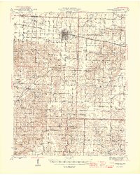
1945 Map of Centralia
USGS Topo · Published 1945About this map
Centralia serves as the primary hub of this North Central Missouri landscape at the end of World War II, situated at the intersection of the Wabash RR and the Wabash Alton rail lines. The surrounding terrain is a dense network of rural school districts and small communities, including Hallsville and the settlement of Hatton. This mid-century survey illustrates a decentralized educational system before the widespread consolidation of the 1950s, naming dozens of local schoolhouses such as Dinwiddie Sch, Angell Sch, and High Hill Sch that anchored local farm life.
Find a feature on this map
69 named features on this map. Tap any name to fly to it.
Don’t see what you’re looking for? This feature index may not catch every label — zoom into the map to look around manually.
Map Details
Editions of this 1945 Centralia Map
2 editions found
Other maps of this area

1886 · Jefferson City
USGS Topo · 1:125,000

1890 · Mexico
USGS Topo · 1:125,000

1890 · Moberly
USGS Topo · 1:125,000

1890 · Fulton
USGS Topo · 1:125,000

1894 · Jefferson City
USGS Topo · 1:125,000

1917 · Sturgeon
USGS Topo · 1:62,500

1928 · Fulton
USGS Topo · 1:62,500

1931 · Fulton
USGS Topo · 1:62,500

1932 · Mexico
USGS Topo · 1:62,500

1935 · Columbia
USGS Topo · 1:24,000