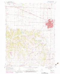
1969 Map of Centralia
USGS Topo · Published 1983About this map
Centralia serves as the focal point of this North Missouri landscape, straddling the border between Audrain and Boone Counties. The city's growth is clearly tied to the Norfolk and Western railroad corridor, which bisects the town and supports local institutions like the Chance Sch and High Sch. Beyond the urban center, the terrain is defined by a dense network of cemeteries and rural landmarks including Fair West Cem, Union Cem, and the Sunnydale Academy to the north.
Find a feature on this map
33 named features on this map. Tap any name to fly to it.
Don’t see what you’re looking for? This feature index may not catch every label — zoom into the map to look around manually.
Map Details
Editions of this 1969 Centralia Map
3 editions found
Other maps of this area

1890 · Moberly
USGS Topo · 1:125,000

1917 · Sturgeon
USGS Topo · 1:62,500

1945 · Centralia
USGS Topo · 1:62,500

1953 · Moberly
USGS Topo · 1:250,000

1953 · Clark
USGS Topo · 1:24,000

1954 · Moberly
USGS Topo · 1:250,000

1957 · Moberly
USGS Topo · 1:250,000

1958 · Tulip
USGS Topo · 1:24,000

1960 · Moberly
USGS Topo · 1:250,000
1960 · Rowena
USGS Topo · 1:24,000