
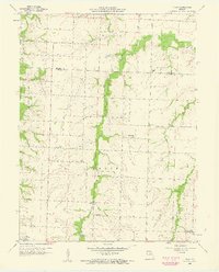
1958 Map of Tulip
USGS Topo · Published 1960About this map
Tulip and Saling sit at the crossing of rural townships in late 1950s Missouri, marking a landscape defined by small-scale farming and local education. This survey captures a network of country schoolhouses that anchored the community before later consolidations, including Friendship Sch, Pine Sch, and Burnham Sch. The terrain is deeply etched by a branching hydrological system where Goodwater Creek and Long Branch wind through the borderlands of Monroe and Audrain counties.
Find a feature on this map
17 named features on this map. Tap any name to fly to it.
Don’t see what you’re looking for? This feature index may not catch every label — zoom into the map to look around manually.
Map Details
Editions of this 1958 Tulip Map
2 editions found
Other maps of this area

1890 · Moberly
USGS Topo · 1:125,000

1917 · Sturgeon
USGS Topo · 1:62,500

1945 · Centralia
USGS Topo · 1:62,500

1952 · Middle Grove
USGS Topo · 1:24,000

1953 · Moberly
USGS Topo · 1:250,000

1953 · Clark
USGS Topo · 1:24,000

1954 · Moberly
USGS Topo · 1:250,000

1957 · Moberly
USGS Topo · 1:250,000
1959 · Madison
USGS Topo · 1:24,000

1960 · Moberly
USGS Topo · 1:250,000