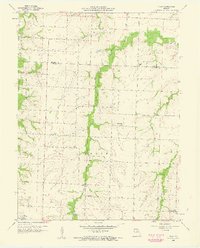
1958 Map of Tulip
USGS Topo · Published 1960About this map
The rolling agricultural divide between the Monroe Co Audrain Co line defines this 1958 survey, showing a landscape of scattered rural settlements and small upland waterways. At the heart of the region sits Tulip, with the small community of Saling located to the south. The area is heavily defined by its educational and spiritual infrastructure, featuring several country schools such as Pine Sch, Friendship Sch, and Burnham Sch, along with the Appleman Ch.
Find a feature on this map
17 named features on this map. Tap any name to fly to it.
Don’t see what you’re looking for? This feature index may not catch every label — zoom into the map to look around manually.
Map Details
Editions of this 1958 Tulip Map
2 editions found
Other maps of this area

1890 · Moberly
USGS Topo · 1:125,000

1917 · Sturgeon
USGS Topo · 1:62,500

1945 · Centralia
USGS Topo · 1:62,500

1952 · Middle Grove
USGS Topo · 1:24,000

1953 · Moberly
USGS Topo · 1:250,000

1953 · Clark
USGS Topo · 1:24,000

1954 · Moberly
USGS Topo · 1:250,000

1957 · Moberly
USGS Topo · 1:250,000

1958 · Tulip
USGS Topo · 1:24,000
1959 · Madison
USGS Topo · 1:24,000