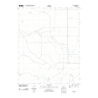
2010 Map of Centro
USGS Topo · Published 2010About this map
The settlement of Centro occupies a high-altitude agricultural landscape in Conejos County, defined by a complex network of water management features. The Alamosa River and Hot Creek descend from the western uplands, feeding an intricate system of gravity-fed irrigation including the Terrace Main Canal, Valdez Ditch Number 5, and Viejo Ditch. This reliance on water storage is evident in the numerous small reservoirs such as Chipmunk Reservoir, Pine Squirrel Reservoir, and Whippoorwill Reservoir that dot the terrain.
Find a feature on this map
31 named features on this map. Tap any name to fly to it.
Don’t see what you’re looking for? This feature index may not catch every label — zoom into the map to look around manually.
Map Details
Editions of this 2010 Centro Map
This is the sole edition of this map. No revisions or reprints were ever made.
Other maps of this area

1922 · Conejos
USGS Topo · 1:125,000

1945 · Durango
USGS Topo · 1:250,000

1953 · Durango
USGS Topo · 1:250,000

1954 · Durango
USGS Topo · 1:250,000

1961 · Durango
USGS Topo · 1:250,000

1963 · Durango
USGS Topo · 1:250,000

1966 · Durango
USGS Topo · 1:250,000
1967 · La Jara Canyon
USGS Topo · 1:24,000
1967 · Centro
USGS Topo · 1:24,000
1967 · Terrace Reservoir
USGS Topo · 1:24,000