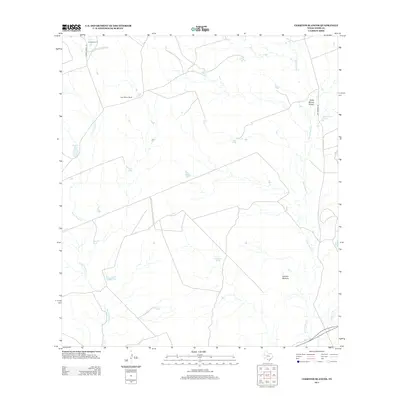
2013 Map of Cerritos Blancos
USGS Topo · Published 2013About this map
Cerritos Blancos and the sprawling livestock operations of Webb County define this South Texas landscape in the early 21st century. The map centers on the traditional ranching economy, where large-scale holdings like Casa Blanca Ranch and La Mesa Ranch rely on a complex network of artificial water sources. Named earthen reservoirs, including Hondo Tank, La Z Tank, and Palo-Blanco Tank, are scattered across the brushland to support cattle where natural flow is ephemeral. Seasonal drainage is dictated by the winding courses of Santa Isabel Cr, Santo Tomas Cr, and the Palito Blanco Arroyo. Remote access to these interior pastures is provided by unpaved corridors such as La Mesa Ranch Rd and Las Tiendas Rd, reflecting the continued isolation and specialized land use of the Rio Grande plain.
Find a feature on this map
17 named features on this map. Tap any name to fly to it.
Don’t see what you’re looking for? This feature index may not catch every label — zoom into the map to look around manually.
Map Details
Editions of this 2013 Cerritos Blancos Map
This is the sole edition of this map. No revisions or reprints were ever made.
Other maps of this area

1923 · Palafox
USGS Topo · 1:62,500

1956 · Las Tiendas
USGS Topo · 1:62,500

1956 · Islitas
USGS Topo · 1:62,500

1956 · Laredo
USGS Topo · 1:250,000

1965 · Spohn Ranch
USGS Topo · 1:24,000

1965 · Cuervo Creek
USGS Topo · 1:24,000

1965 · Cerritos Blancos
USGS Topo · 1:24,000

1965 · Nido Ranch
USGS Topo · 1:24,000
1965 · Dolores Ranch
USGS Topo · 1:24,000
1965 · Las Tiendas
USGS Topo · 1:24,000