
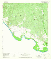
1965 Map of Cuervo Creek
USGS Topo · Published 1967About this map
Rio Grande waters define the southern boundary of this Webb County landscape, where the international border separates Texas and Tamaulipas. In the mid-1960s, the area was characterized by a network of ranchlands and water management features essential for livestock in the semi-arid brush country. Key landmarks include the Retama Ranch and Santa Elena Ranch, along with scattered water sources like Middle Pasture Lake and Big Tank. An Old Railroad Grade cuts across the south-central portion of the map, indicating former transportation corridors that once linked this border region. For local historians and genealogists, the Tordillo Cem and various family-named sites such as Fieldings and Tiendas Windmill provide specific markers of mid-century habitation. The terrain is shaped by drainages like Tordillo Creek and Sombrerito Creek, which flow toward the Rio Grande.
Find a feature on this map
28 named features on this map. Tap any name to fly to it.
Don’t see what you’re looking for? This feature index may not catch every label — zoom into the map to look around manually.
Map Details
Editions of this 1965 Cuervo Creek Map
This is the sole edition of this map. No revisions or reprints were ever made.
Other maps of this area

1956 · Las Tiendas
USGS Topo · 1:62,500

1956 · Islitas
USGS Topo · 1:62,500

1956 · Laredo East
USGS Topo · 1:62,500

1956 · Webb
USGS Topo · 1:62,500

1956 · Laredo
USGS Topo · 1:250,000

1965 · Laredo West
USGS Topo · 1:24,000

1965 · Orvil
USGS Topo · 1:24,000

1965 · Cerritos Blancos
USGS Topo · 1:24,000

1965 · Nido Ranch
USGS Topo · 1:24,000
1965 · Dolores Ranch
USGS Topo · 1:24,000
Featured Places
- Laredo, TX
- Ranchos Penitas West Colonia, TX
- Ranchos Penitas West, TX
- Antonio Santos Colonia, TX
- Los Minerales Colonia, TX