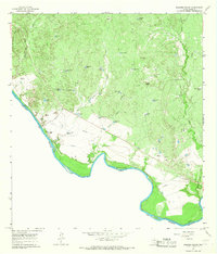
1965 Map of Dolores Ranch
USGS Topo · Published 1967About this map
The Rio Grande defines the character of this West Texas borderlands survey, where the international boundary between the United States and Mexico remained fluid due to the river's shifting course. The landscape is marked by a sophisticated water management system essential for ranching in this arid environment, featuring an extensive network of earthen reservoirs such as Anita Tank, Tasita Tank, and Escondido Tank. Near the riverbanks, an aqueduct and a dedicated Pumping Station supported the operations at Dolores Ranch. Evidence of earlier transport and industry is preserved in the Old Railroad Grade and several Mine Dump sites. For genealogists, the map identifies local burial sites including Darwin Cemetery and Dolores Cemetery, providing spatial context for families associated with the ranching and mining history along the border.
Find a feature on this map
37 named features on this map. Tap any name to fly to it.
Don’t see what you’re looking for? This feature index may not catch every label — zoom into the map to look around manually.
Map Details
Editions of this 1965 Dolores Ranch Map
2 editions found
Other maps of this area

1923 · Palafox
USGS Topo · 1:62,500

1956 · Las Tiendas
USGS Topo · 1:62,500

1956 · Islitas
USGS Topo · 1:62,500

1956 · Laredo
USGS Topo · 1:250,000

1965 · Laredo West
USGS Topo · 1:24,000

1965 · Cuervo Creek
USGS Topo · 1:24,000

1965 · Cerritos Blancos
USGS Topo · 1:24,000

1965 · Nido Ranch
USGS Topo · 1:24,000
1983 · San Pedro Hill
USGS Topo · 1:24,000
1983 · Fort McIntosh 3 NE
USGS Topo · 1:24,000