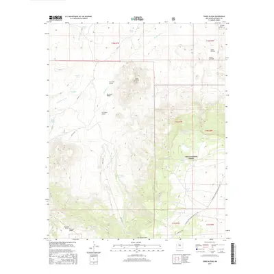
2017 Map of Cerro Alesna
USGS Topo · Published 2017About this map
Cerro Alesna stands as the central landmark of this McKinley County landscape, where the arid high country of the Cibola National Forest is defined by a complex network of canyons and arroyos. The drainage patterns of San Lucas Canyon and San Miguel Canyon illustrate a terrain reliant on seasonal water and scattered perennial sources. Vital water points for travelers and livestock are documented through numerous named features such as San Lucas Spring, San Miguel Spring, and the uniquely named Sap Hole Spring. The eastern portion of the quadrangle is traversed by the Continental Divide National Scenic Trail, which winds through the hills south of Los Barreales Lake. Historical footprints are suggested by Fort Miguel Ruins Spring, indicating earlier habitation or military presence near the headwaters of San Miguel Cr in this sparsely populated region of northwestern New Mexico.
Find a feature on this map
39 named features on this map. Tap any name to fly to it.
Don’t see what you’re looking for? This feature index may not catch every label — zoom into the map to look around manually.
Map Details
Editions of this 2017 Cerro Alesna Map
This is the sole edition of this map. No revisions or reprints were ever made.
Other maps of this area

1883 · Mt. Taylor
USGS Topo · 1:250,000

1886 · Mt. Taylor
USGS Topo · 1:250,000

1892 · Mt. Taylor
USGS Topo · 1:250,000

1899 · Mt. Taylor
USGS Topo · 1:250,000

1958 · Albuquerque
USGS Topo · 1:250,000

1961 · El Dado
USGS Topo · 1:24,000

1961 · Piedra De La Aguila
USGS Topo · 1:24,000

1961 · El Dado Mesa
USGS Topo · 1:24,000
1961 · Laguna Canoneros
USGS Topo · 1:24,000
1961 · Mesa Cortada
USGS Topo · 1:24,000