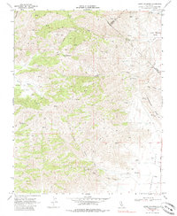
1969 Map of Cerro Colorado
USGS Topo · Published 1985About this map
The Mercey Mine and several other small-scale extraction sites define this 1969 topographic portrait of the San Benito and Fresno county border. The high, arid landscape of the Las Aguilas Mts is marked by a network of primitive transportation routes, including numerous named Jeep Trails and paths that suggest a history of prospecting and ranching. The presence of Lucky Strike Mine, Ely Ray Mine, and Valley View Mine indicates the region's mineral interests, while several Water Tanks and scattered Springs like Vasquez Spring highlight the critical nature of water resources in this dry terrain. Broad topographical features like Glaucophane Ridge and the Real De Las Aguilas grant overlook to the drainage of Little Panoche Creek, showing a landscape largely untouched by modern development and defined by its natural relief and resource-driven exploration.
Find a feature on this map
27 named features on this map. Tap any name to fly to it.
Don’t see what you’re looking for? This feature index may not catch every label — zoom into the map to look around manually.
Map Details
Editions of this 1969 Cerro Colorado Map
3 editions found
Other maps of this area

1913 · Panoche
USGS Topo · 1:125,000

1919 · San Benito
USGS Topo · 1:62,500

1921 · Laguna Seca Ranch
USGS Topo · 1:31,680

1922 · Quien Sabe
USGS Topo · 1:62,500

1923 · Laguna Seca Ranch
USGS Topo · 1:31,680

1931 · San Benito
USGS Topo · 1:62,500

1940 · Quien Sabe
USGS Topo · 1:62,500

1940 · San Benito
USGS Topo · 1:62,500

1943 · Ortigalita Peak
USGS Topo · 1:62,500

1944 · Panoche Valley
USGS Topo · 1:62,500