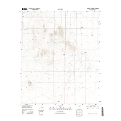
2013 Map of Cerro De La Campana
USGS Topo · Published 2013About this map
Stallion Army Airfield sits at the edge of the high desert basin, marking a intersection of military and ranching history in Socorro County. The landscape is defined by the peaks of Cerro de la Colorado and Cerro de la Campana, which rise above the expansive Jornada del Muerto. This arid terrain is punctuated by isolated human improvements, including the Fite Ranch and water infrastructure like the Pedia Windmill and Red Tank. Significant portions of the land are dedicated to military transport corridors, indicated by WSMR S Route 360 and WSMR P Route 24. Evidence of resource extraction or land management appears in the south with Field Well and Apodaca Well, while the southern reaches of the quadrangle are dominated by the shifting topography of Sand Mtn.
Find a feature on this map
17 named features on this map. Tap any name to fly to it.
Don’t see what you’re looking for? This feature index may not catch every label — zoom into the map to look around manually.
Map Details
Editions of this 2013 Cerro De La Campana Map
This is the sole edition of this map. No revisions or reprints were ever made.
Other maps of this area

1948 · Carthage
USGS Topo · 1:62,500

1948 · Granjean Well
USGS Topo · 1:62,500

1948 · San Antonio
USGS Topo · 1:62,500

1948 · Val Verde
USGS Topo · 1:62,500

1954 · Tularosa
USGS Topo · 1:250,000

1958 · Tularosa
USGS Topo · 1:250,000
1981 · Greens Baber Well
USGS Topo · 1:24,000

1981 · Granjean Well
USGS Topo · 1:24,000
1981 · San Antonio
USGS Topo · 1:24,000
1981 · Canon Agua Buena
USGS Topo · 1:24,000