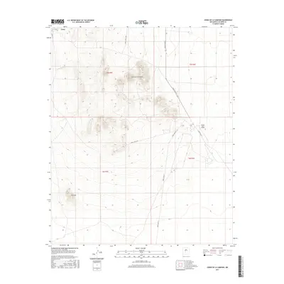
2017 Map of Cerro De La Campana
USGS Topo · Published 2017About this map
Stallion Army Airfield sits within a landscape defined by military transit and arid terrain in this Socorro County survey. The northern edge of the map features the settlement of Tokay, while the central area is dominated by the prominent elevation of Cerro de la Campana. This region is characterized by a network of specialized routes, including WSMR P Route 7 and WSMR S Route 344, which serve the expansive military installations and desert reaches. Water features are sparse, limited to points like Red Tank, illustrating the dry environment of the high desert. To the southwest, Sand Mtn provides a distinct topographic landmark amidst the grid-patterned sections of the White Sands Missile Range periphery. The map effectively captures the intersection of local infrastructure and national defense activities in the New Mexico desert during the early twenty-first century.
Find a feature on this map
15 named features on this map. Tap any name to fly to it.
Don’t see what you’re looking for? This feature index may not catch every label — zoom into the map to look around manually.
Map Details
Editions of this 2017 Cerro De La Campana Map
This is the sole edition of this map. No revisions or reprints were ever made.
Other maps of this area

1948 · Carthage
USGS Topo · 1:62,500

1948 · Granjean Well
USGS Topo · 1:62,500

1948 · San Antonio
USGS Topo · 1:62,500

1948 · Val Verde
USGS Topo · 1:62,500

1954 · Tularosa
USGS Topo · 1:250,000

1958 · Tularosa
USGS Topo · 1:250,000
1981 · Greens Baber Well
USGS Topo · 1:24,000

1981 · Granjean Well
USGS Topo · 1:24,000
1981 · San Antonio
USGS Topo · 1:24,000
1981 · Canon Agua Buena
USGS Topo · 1:24,000