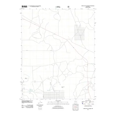
2011 Map of Cerro De Los Taoses
USGS Topo · Published 2011About this map
Cerro de los Taoses and Cerrito Dormilon define the high-desert topography of this Taos County landscape in the early twenty-first century. The area is characterized by seasonal water management and an emerging network of rural access roads. Key water resources like Taoses Tank, Aquate Tank, and Sertion Three Tank indicate a land used for ranching and livestock, where surface water is carefully captured. The drainage of Arroyo Aguaje de la Petaca cuts through the terrain, while newer residential or ranching tracks such as Coyote Moon Rd and 2 Hawks Trl branch off from the more established Wolf Springs Ranch Rd. This U.S. Geological Survey record captures the transition of the high-altitude basin as traditional land uses meet modern rural subdivision and naming conventions.
Find a feature on this map
9 named features on this map. Tap any name to fly to it.
Don’t see what you’re looking for? This feature index may not catch every label — zoom into the map to look around manually.
Map Details
Editions of this 2011 Cerro De Los Taoses Map
This is the sole edition of this map. No revisions or reprints were ever made.
Other maps of this area

1954 · Raton
USGS Topo · 1:250,000

1958 · Raton
USGS Topo · 1:250,000

1961 · Tres Orejas
USGS Topo · 1:24,000

1961 · Servilleta Plaza
USGS Topo · 1:24,000

1963 · Arroyo Hondo
USGS Topo · 1:24,000

1963 · Tres Piedras NE
USGS Topo · 1:24,000

1963 · Cerro De Los Taoses
USGS Topo · 1:24,000

1963 · Guadalupe Mountain
USGS Topo · 1:24,000
1963 · Petaca Peak
USGS Topo · 1:24,000
1963 · Tres Piedras
USGS Topo · 1:24,000