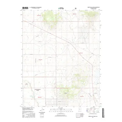
2017 Map of Cerro De Los Taoses
USGS Topo · Published 2017About this map
The high-desert terrain of Carson National Forest dominates this northern New Mexico landscape, centered around the volcanic rise of Cerro de los Taoses. Modern rural development is visible through a network of named tracks and private roads such as Coyote Moon Rd, Stagecoach Rd, and Wolf Springs Ranch Rd, which weave through the arid brushland.
Find a feature on this map
25 named features on this map. Tap any name to fly to it.
Don’t see what you’re looking for? This feature index may not catch every label — zoom into the map to look around manually.
Map Details
Editions of this 2017 Cerro De Los Taoses Map
This is the sole edition of this map. No revisions or reprints were ever made.
Other maps of this area

1954 · Raton
USGS Topo · 1:250,000

1958 · Raton
USGS Topo · 1:250,000

1961 · Tres Orejas
USGS Topo · 1:24,000

1961 · Servilleta Plaza
USGS Topo · 1:24,000

1963 · Arroyo Hondo
USGS Topo · 1:24,000

1963 · Tres Piedras NE
USGS Topo · 1:24,000

1963 · Cerro De Los Taoses
USGS Topo · 1:24,000

1963 · Guadalupe Mountain
USGS Topo · 1:24,000
1963 · Petaca Peak
USGS Topo · 1:24,000
1963 · Tres Piedras
USGS Topo · 1:24,000