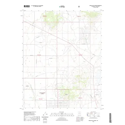
2020 Map of Cerro De Los Taoses
USGS Topo · Published 2020About this map
The high-desert terrain of northern New Mexico is defined here by volcanic landforms and the managed lands of the Carson National Forest. Notable peaks such as Cerro de los Taoses and Cerrito Dormilon rise above the surrounding plateau, providing landmarks in a landscape etched by seasonal drainages like Arroyo Aguaje de la Petaca. This area demonstrates the vital importance of water management in an arid environment, as seen in the scattered livestock or wildlife watering points including Aquate Tank, Taoses Tank, and Sertion Three Tank. A network of modern and local routes, such as Stagecoach Rd and Hole Springs Ranch Rd, traces the path of contemporary development and historical movement through this portion of Taos County, while more recent additions like Coyote Moon Rd and Farthship Way reflect the evolving settlement patterns of the region.
Find a feature on this map
25 named features on this map. Tap any name to fly to it.
Don’t see what you’re looking for? This feature index may not catch every label — zoom into the map to look around manually.
Map Details
Editions of this 2020 Cerro De Los Taoses Map
This is the sole edition of this map. No revisions or reprints were ever made.
Other maps of this area

1954 · Raton
USGS Topo · 1:250,000

1958 · Raton
USGS Topo · 1:250,000

1961 · Tres Orejas
USGS Topo · 1:24,000

1961 · Servilleta Plaza
USGS Topo · 1:24,000

1963 · Arroyo Hondo
USGS Topo · 1:24,000

1963 · Tres Piedras NE
USGS Topo · 1:24,000

1963 · Cerro De Los Taoses
USGS Topo · 1:24,000

1963 · Guadalupe Mountain
USGS Topo · 1:24,000
1963 · Petaca Peak
USGS Topo · 1:24,000
1963 · Tres Piedras
USGS Topo · 1:24,000